
Orienteering

Section Menu
Steve Sanders organises an informal orienteering league for the club using the MapRun system. Steve sets courses in the local area, some urban, some rural or fell, and anyone can run them at any time. Details on how to join in are further down this page.
Maps are drawn up by Steve (under licence from Ordnance Survey) and posted below, showing the checkpoints and any out-of-bounds areas. As runners complete courses their scores are recorded by the MapRun system, collated by Steve and posted below.
2025 Series
The series run from 1 April to 30 November. There are 8 different courses, each with its own time limit between 30 and 90 minutes, made available progressively through the year, with scores only counting towards the league during set two-month periods. Steve will email the courses to the club mailing list shortly before the start of each period; if you run the courses outside the specified time window the results won't count towards the league. Previous courses are still available (contact Steve for the maps) if you want to do them.
They are score events: collect as many points as you can before returning to the start within the allotted time limit. There is a penalty of –10 points for every minute (or part of a minute) late back so someone scoring 100 points would lose them all if they were 10 minutes over time.
You can only get the points for a control once, even if you run to it several times.
The naming of the controls shows how many points they are worth (01 to 09 = 10 points, 11 to 19 = 20 points, 21 to 29 = 30 points, 31 to 39 = 40 points, etc).
Your best 6 scores will be summed to determine your final score for the series. Where people finish with the same number of points, the runner with the lowest average time (time as a proportion of the permitted time for the course) across their best 6 courses will be placed ahead in the table.
Results
- Elsecar 60 min
- Hartcliff 40 min
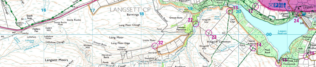
- Langsett 60 min
- Winscar 80 min
- Broomhead 80 min
- Hugset 50 min
- Bradfield 80 min
- Denby 60 min
2024 course results
- Ingbirchworth 60 min
- Tankersley 40 min
- Bolsterstone 60 min
- Fiddlers Green 90 min
- Higham 60 min
- Strines 60 min
- Cawthorne 40 min
- Penistone 40 min
2023 course results
- Millhouse 60 min
- Penistone 45 min
- Low Bradfield 75 min
- Upper Denby 60 min
- Hood Green 60 min
- Wortley 80 min
- Hoylandswaine 45 min
- Winscar 90 min
How to take part
There’s a user guide on the MapRun website which should get you set up. If you have any problems contact Steve.
You will need to download the app (either MapRun6 or MapRun is fine – MapRun is the latest version) to your phone and enter a username. You will need to make sure the app has access to location and data settings. The app needs to be able to run in the background. Once started with the app you can then search for the event. The simplest way is to use “select event”. This will take you through a series of folders: UK –> South Yorkshire –> PFRAC –> 2025 and select the course you want to run. The details in grey under the name just specify the course type and rules.
You then simply select “Go To Start” where you will need to enter the PIN which is printed on the map. The map will load up on the screen and you can zoom in and out but the important thing to look for is the bar at the bottom of the screen where it says “GPS”. This bar must be green before setting off to confirm the app has a GPS signal. Once you have a green GPS status bar then just set off on the course. The app will beep, and start timing, as soon as you pass through the start/finish point.
As soon as you cross back through the start/finish the app will stop your time (even if you’ve not been to any controls so once you’ve set off be sure not to turn back straight away). Your phone should beep when you get to a control (or near to it) but don’t worry if it doesn’t. If you don’t hear a beep carry on your run and Steve can sort it out afterwards.
Once you have finished your run you tap “Show Results”, select the course and then tap the three lines to get the menu. From here select “Review Results (HITMO)”. It’ll list the controls with any you visited in green. If the app thinks you've been close to a checkpoint but not close enough it will be in red and you tick the box at the side of it and then select “Submit a revised result” at the bottom of the screen. Your result will be updated with (Revxx) at the side of it and Steve can then check it for you. You may need to increase the punch tolerance (this is the xx in the Revxx above) – ie if you set it to 30m tolerance then the results would show Rev30.
For anyone who doesn’t want to (or isn’t able to) use the app, you can just record your run on a watch and email the GPX file to Steve (downloadable from the activity on Strava/Garmin/Suunto etc). There is also an option to use a Garmin watch with MapRunG loaded onto it, which means you can run without your phone, the watch beeps when you reach a checkpoint and will upload to MapRun when you sync your run. Another option within the app allows you to upload a track from Strava instead of using the app to record the run. Instructions are available on the MapRun website.