
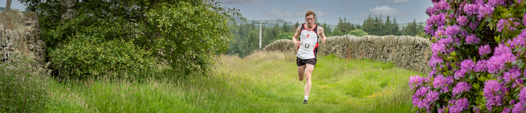
Barnsley Boundary Relay

Section Menu
- Start Date/Time
- 15 June 2024 at 08:00 – see below for individual leg start times
- Category
- Multi-terrain relay
- Distance
- Approximately 72/115km miles with 7,350ft//2,240m of ascent, over 10 legs
- Organiser
- Steve Dickinson (steve@osi.uk.com) – 07850 445613. Contact Steve if interested in entering a team.
The Barnsley Boundary Relay Race is a multi-terrain race following the boundary of Barnsley MBC, using the route of the Barnsley Boundary Long Distance Path. It is a race for teams of 10, each running legs on roads, tracks and footpaths of between 4 and 11½ miles: 72 miles in total.
It is organised by Penistone Footpath Runners in conjunction with Barnsley Rockley Rotary Club and with the support of other local running clubs.
Entries are welcome from any running clubs, organisations or businesses. Some legs require some navigation or previous knowledge – there are plenty of opportunities to be shown the way before the day. It is an sociable event.
GPX files and maps are available for all 10 legs below. If you had previously downloaded files from here you are advised to replace them with the current ones: all 10 were checked on the ground in April 2021.
The race is run under a England Athletics licence and minimum ages apply based on the distance of each leg: the minimum age for legs 1, 5, 8 and 10 is 16 and for all other legs is 17.
The Route
The first leg starts at 8am. The second leg starts when the first runner reaches the end of leg 1. All leg 2 runners set off together, and so on through the race. Times for each leg are aggregated at the end of the race and the fastest teams in each category (Men, M40+, M50+, M60+, Ladies, L40+ and Mixed) announced at the prize ceremony, which is held in the evening after the race.
An ordnance survey map, aerial photography and GPX files for the whole route are available on the Barnsley Boundary Walk website. Note that the race route does not always follow the same route as marked on the Ordnance Survey maps or the Walking Guides.
The links below give maps and GPX files for each leg. The GPX files can be downloaded and imported into GPS software, or uploaded to a phone or watch.
| Leg | Start time (approx) | Distance/climb |
|---|---|---|
| 1: Cannon Hall to Bretton Park | 08:00 | 5.1M/528' |
| Start: S75 4AR / SE 27283 07944 | Map | GPX |
| 2: Bretton Park to Brierley | 08:30 | 10.4M/768' |
| Start: S75 4BZ / SE 29960 12013 | Map | GPX |
| 3: Brierley to Thurnscoe | 09:40 | 6.6M/459' |
| Start: S72 9JX / SE 40468 11116 | Map | GPX |
| 4: Thurnscoe to Brampton | 10:20 | 6.4M/196' |
| Start: S63 0BH / SE 46513 05383 | Map | GPX |
| 5: Brampton to Tankersley | 11:00 | 5.1M/486' |
| Start: S73 0SS / SE 41050 02197 | Map | GPX |
| 6: Tankersley to Wortley Station | 11:30 | 11.4M/1620' |
| Start: S74 0DU / SK 34896 99492 | Map | GPX |
| 7: Wortley Station to Langsett Barn | 12:45 | 6.5M/1074' |
| Start: S35 7DL / SK 29861 99246 | Map | GPX |
| 8: Langsett Barn to Winscar Reservoir | 13:40 | 5.7M/814' |
| Start: S36 4GY / SE 21082 00444 | Map | GPX |
| 9: Winscar Reservoir to Upper Denby | 14:20 | 10.5M/1188' |
| Start: S36 4TF / SE 15296 02048 | Map | GPX |
| 10: Upper Denby to Cannon Hall | 15:30 | 4.0M/210' |
| Start: HD8 8UE / SE 22927 07366 | Map | GPX |
If anyone finds any errors in the GPX files, please contact Paul Fryers.
Results
2015 2016 2017 2018 2019 2021 2022 2023
The race in 2020 was cancelled.